
Reverse Geocoding: Convert Coordinates to Addresses

Reverse Geocoding: How Coordinates Become Readable Addresses
A delivery driver's app shows a pin on a map. A weather service reports conditions for your neighborhood. A photo's EXIF data reveals where it was taken. None of these would be useful without reverse geocoding — the process of turning raw latitude and longitude coordinates into a human-readable address or place name.
This guide explains how reverse geocoding works, where accuracy breaks down, how it differs from IP-based geolocation, and what it means for your privacy.
What Is Reverse Geocoding?
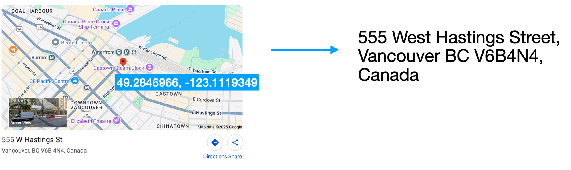
Reverse Geocoding: Convert Coordinates to Addresses - What Is Reverse Geocoding?.
Reverse geocoding converts a geographic coordinate pair (latitude, longitude) into a description of that location: a street address, a neighborhood, a city, a postal code, or a country. It is the inverse of forward geocoding, which takes a text address and returns coordinates.
According to the Wikipedia entry on reverse geocoding, the output is not always a precise house number. Depending on the data source, it may return:
- A street address interpolated from a range (e.g., "near 50 Main Street")
- A neighborhood or administrative subdivision
- A city, state, or country name
- A nearby landmark or point of interest
Because the result depends on the reference dataset, two services can return different answers for the same coordinate.
How Reverse Geocoding Works Under the Hood
Reverse Geocoding: Convert Coordinates to Addresses - How Reverse Geocoding Works Under the Hood.
Most reverse geocoders follow a similar pipeline:
- Input — You provide a coordinate pair, either typed manually, captured by GPS, or selected on a map.
- Spatial lookup — The service queries a reference dataset (road networks, address points, administrative boundaries) to find the nearest matching feature.
- Interpolation — If the coordinate falls along a road segment with a known address range, the system estimates a house number.
- Formatting — The result is returned as structured components (street, city, postcode, country) and often a formatted address string.
Some services also return the distance between your input coordinate and the matched address, which helps you judge how close the estimate is.
The Role of Data Sources
Reverse geocoding quality depends heavily on the underlying map data. Common sources include:
- OpenStreetMap and OpenAddresses for open, community-maintained data
- National postal and cadastral databases for official address points
- Commercial providers that combine multiple sources with proprietary corrections
A coordinate in a dense city with well-mapped addresses will usually resolve to a precise street address. The same coordinate in a rural area or a country with sparse address data may only resolve to a village or region.
Reverse Geocoding vs. IP Geolocation

Reverse Geocoding: Convert Coordinates to Addresses - Reverse Geocoding vs. IP Geolocation.
It is easy to confuse reverse geocoding with IP geolocation, but they answer different questions:
| Reverse Geocoding | IP Geolocation | |
|---|---|---|
| Input | Latitude and longitude | An IP address |
| Output | Street address, place name | Approximate city, region, ISP |
| Typical accuracy | Meters to hundreds of meters | City-level, sometimes neighborhood |
| Common use | Maps, logistics, photo tagging | Fraud detection, content localization, analytics |
IP geolocation does not use coordinates you provide. It estimates a location from network routing data, which is why it is usually far less precise than reverse geocoding. If you want to see what your own IP address reveals about you, a tool like BrowserScan's IP lookup can show your detected location, ISP, and whether a proxy or VPN is in use.
Practical Uses of Reverse Geocoding

Reverse Geocoding: Convert Coordinates to Addresses - Practical Uses of Reverse Geocoding.
Reverse geocoding powers many everyday services:
- Navigation and ride-hailing — Apps convert your GPS position into a pickup address.
- Emergency response — Enhanced 911 systems translate cell coordinates into dispatchable addresses.
- Photo and video metadata — Cameras and phones embed coordinates; software can display the place name.
- Logistics and delivery — Fleets verify that a scanned coordinate matches the intended drop-off point.
- Data analysis — Researchers aggregate coordinates into neighborhoods or regions for mapping and reporting.
For developers, reverse geocoding is typically consumed through an API. Free and paid tiers exist, and batch tools let you upload a CSV or Excel file of coordinates and download the resolved addresses. For example, Geoapify's online reverse geocoding tool accepts files and returns addresses with distance values, while LatLong.net's converter handles single coordinate pairs interactively.
Accuracy Limits and Common Pitfalls
Reverse geocoding is an estimate, not a survey. Keep these limitations in mind:
- Interpolation is not exact. A house number derived from a road segment range may be off by several buildings.
- Rural and informal addresses are often missing from datasets.
- Coordinate precision matters. Rounding latitude and longitude to two decimal places can shift your location by more than a kilometer.
- Different providers, different answers. Always note which dataset and version produced a result.
- Distance values help. If a service returns the distance to the matched address, treat large values as a warning sign.
When precision matters — legal, medical, or emergency contexts — verify the result against a second source or a map.
Privacy: What Your Coordinates Reveal
Coordinates are sensitive. A single latitude and longitude pair can identify a home, a workplace, or a route. Wikipedia's article notes that researchers have reconstructed individual locations from published maps by georeferencing them, and that blurring or shifting points is sometimes proposed as a safeguard.
The privacy risk extends beyond coordinates you type in deliberately:
- Photos may carry GPS data in EXIF fields.
- Browser fingerprinting can combine timezone, language, and other signals to infer your region.
- VPN leaks can expose your real IP and, through IP geolocation, your approximate location even when you expect to be masked.
If you use a VPN for location privacy, it is worth checking whether your setup actually hides your origin. BrowserScan's privacy tools guide explains how to verify browsers, VPNs, and DNS settings, and a BrowserScan setup walkthrough shows how to run a free fingerprint, DNS, and WebRTC leak check in minutes.
How to Reverse Geocode a Coordinate Yourself
You do not need to write code to try it:
- Get the coordinate. Copy it from a map, a photo's metadata, or a GPS device. Keep at least five decimal places if you can.
- Choose a tool. Use a single-point converter for one location or a batch uploader for many.
- Read the components. Look at street, city, postcode, and country separately — not just the formatted string.
- Check the distance. If the tool reports how far the matched address is from your input, use it to judge reliability.
- Cross-check. Paste the coordinate into a map and confirm the pin lands where you expect.
For developers, the same steps apply through an API: send the coordinate, parse the structured response, and handle cases where no address is found.
Related reading
- Privacy Tools: What They Are and How to Verify Yours - A practical guide to privacy tools: browsers, VPNs, DNS, password managers, and free tests that verify your setup actually protects you.
- NordVPN Pricing Explained: Plans, Costs, and Real Value - Compare NordVPN pricing across monthly, yearly, and 2-year plans, see what each tier includes, and learn how to verify your VPN actually protects you.
- Pixelscan Tutorial: Run and Read a Fingerprint Test - Step-by-step Pixelscan tutorial: run the check, read each result category, spot fingerprint mismatches, and verify your setup with a second tool.
FAQ
What is reverse geocoding in simple terms?
It is the process of turning latitude and longitude coordinates into a readable address or place name, such as "1600 Pennsylvania Avenue" or "Shibuya, Tokyo."
Is reverse geocoding the same as geocoding?
No. Geocoding converts an address into coordinates. Reverse geocoding converts coordinates into an address. They are opposites.
How accurate is reverse geocoding?
Accuracy ranges from a few meters in well-mapped urban areas to several kilometers in rural or sparsely mapped regions. Results are estimates based on the provider's reference data.
Can reverse geocoding identify a specific person?
Not directly, but a precise coordinate can point to a home or workplace. Combined with other data, that can contribute to identifying an individual, which is why location data deserves careful handling.
Does a VPN affect reverse geocoding?
A VPN changes your IP address, which affects IP geolocation, not reverse geocoding of coordinates you enter. However, if your VPN leaks your real IP through DNS or WebRTC, IP-based location estimates can still reveal your approximate region.
What is the difference between reverse geocoding and IP geolocation?
Reverse geocoding uses coordinates you provide and can return a street-level address. IP geolocation uses your network address and typically returns only a city or region.
Conclusion
Reverse geocoding is the bridge between raw coordinates and the addresses people actually understand. It powers maps, deliveries, emergency services, and data analysis — but it is always an estimate shaped by the quality of the underlying data.
Use it with realistic expectations: check the returned components, watch the distance values, and cross-reference when precision matters. And because coordinates are inherently personal, treat location data as sensitive — whether it comes from a photo, a GPS trace, or the network signals your browser exposes. A quick privacy check is a small step that can prevent a precise location from ending up where you did not intend.