
Location Intelligence: What It Is, How It Works & Use Cases
Location Intelligence: Turning Geospatial Data into Smarter Decisions
Every transaction, delivery, sensor reading, and mobile check-in carries a hidden signal: where it happened. Location intelligence (LI) is the practice of extracting meaningful insights from that spatial context, then using those insights to guide decisions. It sits at the intersection of traditional business intelligence, geographic information systems (GIS), and modern data analytics—helping organizations answer not just what happened, but where, why, and what to do next.
This guide explains what location intelligence really means, how it differs from related disciplines, the data that powers it, and the practical ways organizations apply it. Whether you are evaluating spatial tools, building a site selection model, or simply trying to understand the terminology, you will find a clear, grounded overview here.
What Is Location Intelligence?
Location Intelligence: What It Is, How It Works & Use Cases - What Is Location Intelligence?.
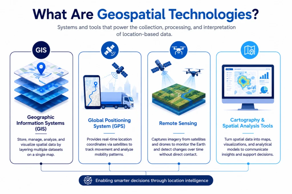
Location intelligence is the insight gained from visualizing and analyzing geospatial data. It involves layering location-specific information—such as demographics, traffic patterns, environmental conditions, economic indicators, and weather—onto maps or dashboards to reveal relationships that would otherwise remain hidden in spreadsheets.
At its core, LI answers spatial questions:
- Where should we open the next storefront based on foot traffic and competitor density?
- Which communities face the highest flood risk under different climate scenarios?
- How can we reroute delivery fleets in real time to reduce fuel costs?
- What geographic patterns appear in fraud or transaction data?
Unlike a static map that simply displays points, location intelligence involves analysis: comparing layers, detecting clusters, modeling scenarios, and producing actionable outputs. As Esri defines it, LI is the insight gained from visualizing and analyzing geospatial data to understand where and why things are happening and plan what to do next.
Location Intelligence vs. GIS vs. Business Intelligence
Location Intelligence: What It Is, How It Works & Use Cases - Location Intelligence vs. GIS vs. Business Intelligence.
These three terms are often used interchangeably, but they describe distinct layers of capability.
GIS: The Foundation
A geographic information system is the underlying technology that captures, stores, manages, and visualizes spatial data. GIS tools let users create interactive queries, edit geographic datasets, integrate map layers, and present results. Without GIS, geospatial datasets are too large and complex to interpret manually.
Business Intelligence: The Broader Context
Business intelligence (BI) ingests business data—sales, inventory, customer records, marketing performance—and presents it in dashboards and reports. Traditional BI tools handle temporal and categorical data well but often struggle with spatial relationships. A BI dashboard can tell you that sales fell 12% last quarter; it cannot easily show you where they fell or why geography mattered.
Location Intelligence: The Spatial Layer
Location intelligence extends BI by adding the spatial dimension. As CARTO explains, BI focuses on static and temporal data, while LI revolves around location-first analyses. BI answers "what happened" and "where things are"; LI pushes further into "why" and "what if."
Here is a practical comparison:
| Capability | Business Intelligence | Location Intelligence |
|---|---|---|
| Primary data focus | Temporal, categorical | Spatial, location-first |
| Typical output | Charts, tables, dashboards | Maps, spatial models, geospatial dashboards |
| Questions answered | What happened? When? | Where? Why there? What if we change location? |
| Analysis depth | Aggregation, filtering | Spatial joins, clustering, proximity analysis, predictive modeling |
| Typical users | Business analysts, executives | GIS analysts, data scientists, planners, operations teams |
LI does not replace BI. The most effective organizations integrate both: BI provides the operational metrics, and LI adds the geographic context that makes those metrics meaningful.
Key Data Sources for Location Intelligence
Location Intelligence: What It Is, How It Works & Use Cases - Key Data Sources for Location Intelligence.
Location intelligence draws on a wide range of data types. Understanding where the data comes from helps you assess quality, coverage, and suitability for specific use cases.
Core Geospatial Data
Geospatial data combines three components: location information (coordinates), attribute information (characteristics of the object or event), and temporal information (when the location and attributes exist). The two primary formats are:
- Vector data: Points, lines, and polygons represented by x/y coordinates. Examples include store locations, road networks, and administrative boundaries.
- Raster data: Grids or cells of pixels with spatial values attached to each cell. Examples include satellite imagery, elevation models, and temperature surfaces.
Common Data Sources
Organizations typically combine internal and external sources:
- Internal business data: CRM records, loyalty card transactions, ecommerce shipping addresses, sales territories, and asset locations.
- Public and open data: Census demographics, government administrative boundaries, land use records, and publicly available environmental datasets.
- Sensor and IoT data: GPS devices, fleet telematics, smart meters, weather stations, and traffic sensors.
- Remote sensing: Satellite imagery, aerial photography, LiDAR scans, and drone captures.
- Premium data streams: Human mobility patterns, points of interest, road traffic feeds, climate projections, and housing market data.
The rise of IoT has dramatically increased the volume of location-tagged data available for analysis. Billions of connected devices continuously emit coordinates, timestamps, and sensor readings, creating rich streams for real-time LI applications.
How Location Intelligence Works in Practice

Location Intelligence: What It Is, How It Works & Use Cases - How Location Intelligence Works in Practice.
A typical location intelligence workflow follows a repeatable pattern:
- Data collection: Gather spatial data from internal systems, public sources, and third-party providers.
- Data preparation: Clean, geocode, and standardize addresses and coordinates. Convert data into usable vector or raster formats.
- Spatial analysis: Apply analytical techniques such as buffering, spatial joins, clustering, hotspot detection, network routing, and suitability modeling.
- Visualization: Present results through interactive maps, dashboards, and reports that decision-makers can explore.
- Integration and action: Feed insights back into operational systems—CRM platforms, routing software, risk models, or strategic planning processes.
Modern LI platforms increasingly run in cloud-native environments, allowing spatial analysis to happen directly on data warehouses without moving data between systems. This reduces governance overhead and accelerates iterative analysis.
Major Use Cases Across Industries
Location intelligence applies wherever "where" matters. Here are the most common applications.
Retail and Site Selection
Retailers use LI to evaluate potential store locations based on foot traffic, demographic profiles, competitor proximity, and accessibility. The same analysis supports network optimization—deciding where to open, relocate, or close locations to maximize coverage and minimize cannibalization.
Supply Chain and Logistics
Routing optimization is one of the most mature LI applications. By analyzing real-time traffic data, delivery windows, vehicle capacity, and driver availability, logistics teams can reduce mileage, improve on-time performance, and lower fuel costs. Warehouse site selection uses similar spatial modeling to position facilities closer to customer demand centers.
Marketing and Customer Segmentation
When location analytics integrate with CRM data, marketers can segment customers by geography, adjust pricing and messaging by region, and identify underserved areas for campaign expansion. Geomarketing uses spatial patterns in purchasing behavior to target promotions more effectively.
Energy and Utilities
Utility companies analyze vegetation growth, weather patterns, and asset locations to predict outage risks and prioritize maintenance. Spatial models also support energy demand forecasting and the planning of renewable infrastructure such as solar farms and wind installations.
Transportation and Urban Planning
Cities use LI to model traffic flows, plan public transit routes, and assess the impact of new developments. Real-time spatial data enables smart transportation systems that adjust signals, reroute buses, and inform commuters.
Insurance and Risk Assessment
Insurers overlay property locations with flood zones, wildfire risk maps, seismic data, and climate projections to price policies accurately and manage portfolio exposure. Spatial analysis helps identify concentration risk—too many insured assets in a single high-hazard area.
Public Health and Government
Health agencies map disease outbreaks, vaccination coverage, and healthcare facility accessibility. Governments use LI for emergency response planning, infrastructure investment prioritization, and social equity analysis.
The Role of AI in Location Intelligence
Artificial intelligence is accelerating LI in several ways:
- Predictive modeling: Machine learning models trained on historical spatial data can forecast demand, risk, or traffic patterns.
- Natural language search: Users can ask questions in plain language—"show me underserved areas in zip code 30318"—and receive map-based answers without writing spatial queries.
- Automated feature extraction: AI can identify objects, land use patterns, and changes from satellite imagery at scale.
- Anomaly detection: Spatial ML models flag unusual patterns in transaction data, sensor readings, or network activity.
These capabilities make spatial analysis accessible to non-GIS specialists, reducing the bottleneck that traditionally limited LI adoption to dedicated geospatial teams.
Challenges and Considerations
Despite its value, location intelligence presents real challenges:
- Data fragmentation: Spatial data often lives in siloed GIS tools, separate from the data warehouses that power BI. This creates governance headaches and slows analysis.
- Data quality: Geocoding errors, inconsistent address formats, and outdated boundary files can undermine results.
- Privacy concerns: Location data is inherently sensitive. Organizations must handle it with strong governance, anonymization, and compliance with regulations like GDPR and CCPA.
- Skill gaps: Traditional GIS expertise is specialized. Cloud-native LI platforms with low-code interfaces help bridge this gap, but organizations still need people who understand spatial concepts.
- Scale: Geospatial datasets are large. Processing them efficiently requires appropriate infrastructure and query optimization.
How Location Intelligence Relates to Online Privacy and IP Geolocation
Location intelligence in the enterprise context focuses on business and societal questions. But location data also plays a critical role in the digital privacy landscape. Every internet connection carries an IP address that can be geolocated to a city, region, or ISP. Understanding what your IP address reveals is a practical, personal form of location awareness.
If you use a VPN to protect your privacy, verifying that your real location is not leaking through DNS or WebRTC is essential. Tools like BrowserScan provide free, browser-based diagnostics that show what your IP address exposes—including geolocation, ISP, and proxy detection—and whether your VPN is actually hiding your true location. For a deeper walkthrough, see this BrowserScan tutorial on checking browser fingerprints and leaks.
This connection matters because the same principle underlying enterprise LI—location data reveals patterns and insights—applies to your digital footprint. Knowing what your connection broadcasts is the first step toward controlling it. If you are evaluating VPN services, our guide on what a personal VPN does and how to test one covers the essentials of verifying your connection for leaks.
Choosing a Location Intelligence Approach
There is no single "best" LI tool. The right approach depends on your organization's scale, data stack, and use cases.
When to Use Traditional GIS Platforms
Dedicated GIS software such as ArcGIS remains the standard for complex spatial modeling, cartographic production, and government-scale projects. If your team includes GIS specialists and you need deep analytical control, a full GIS platform is appropriate.
When to Use Cloud-Native LI Platforms
Cloud-native platforms like CARTO integrate directly with data warehouses such as Snowflake, BigQuery, and Redshift. They are designed for data analysts and data scientists who want spatial capabilities without managing separate GIS infrastructure. This approach works well when LI must scale alongside existing BI workflows.
When to Extend Existing BI Tools
Some BI platforms now include basic mapping capabilities. If your spatial questions are simple—plotting points, filtering by region—extending your current BI stack may be sufficient. However, when you need spatial joins, proximity analysis, or predictive spatial modeling, dedicated LI capabilities become necessary.
Evaluation Criteria
When evaluating options, consider:
- Data integration: Does the platform connect to your existing data warehouse and third-party data sources?
- Analytical depth: Does it support the spatial operations you need—routing, clustering, suitability modeling?
- Scalability: Can it handle your data volume without performance degradation?
- Accessibility: Can non-GIS users create and interpret spatial analyses?
- Governance: Does it provide the access controls and audit trails your compliance requirements demand?
Related reading
- BrowserLeaks Pricing: Free Tools vs Paid API Plans - Understand BrowserLeaks pricing across free leak tests, planned subscription tiers, and API costs. See what you actually pay and free alternatives.
- How to Use Nmap: The Network Mapper Free Security Scanner - Learn how to use Nmap, the free open-source network mapper, for port scanning, host discovery, OS detection, and security auditing with practical examples.
- Online Anonymity: What It Really Means and How to Test Yours - Learn what online anonymity really means, why it matters, the tools people use to achieve it, and how to test whether your identity is actually protected.
Sources and further reading
- What Is Location Intelligence? | IBM - Location intelligence is the method of gaining insights from geospatial data.
Frequently Asked Questions
What is the difference between location intelligence and GIS?
GIS refers to the systems and infrastructure used to collect, manage, and analyze spatial data. Location intelligence focuses on turning that data into actionable insights, emphasizing accessibility, real-time analysis, and integration with broader business systems. They are complementary rather than competing concepts.
Can location intelligence be used without a GIS team?
Yes. Modern cloud-native LI platforms are designed for data analysts, data scientists, developers, and business users. Low-code interfaces, AI-assisted querying, and warehouse-native architecture allow organizations to scale spatial capabilities without deep in-house geospatial expertise.
What industries benefit most from location intelligence?
Most industries ask questions with a "where" component at some point. Retail, logistics, insurance, financial services, telecommunications, real estate, energy, and government are among the heaviest users. Estimates suggest that roughly 80% of all data has a location component.
What types of data are used in location intelligence?
Location data includes addresses, latitude/longitude coordinates, points, lines, polygons, and administrative units. Organizations also use internal data from CRM and ecommerce systems, publicly available open data, and premium streams such as human mobility, traffic, weather, climate, and housing data.
How is AI changing location intelligence?
AI makes spatial analysis faster and more accessible. Natural language search lets non-technical users query spatial data conversationally. Machine learning enables predictive modeling, anomaly detection, and automated feature extraction from imagery. AI also automates complex workflows that previously required manual GIS expertise.
Does location intelligence raise privacy concerns?
Yes. Location data is highly sensitive and can reveal personal patterns, routines, and associations. Organizations must implement strong data governance, anonymization where possible, and compliance with privacy regulations. On the individual side, understanding what your IP address and browser fingerprint reveal is an important step in protecting your own location privacy.
Conclusion
Location intelligence transforms raw geospatial data into decisions. It extends business intelligence with the spatial context that traditional dashboards miss, enabling organizations to answer "where" and "why there" questions with analytical rigor. From retail site selection to supply chain optimization, insurance risk modeling to urban planning, LI provides a competitive advantage by revealing patterns that only become visible when data is placed on a map.
The field is evolving rapidly. Cloud-native platforms are breaking down silos between GIS and BI. AI is making spatial analysis accessible to non-specialists. And the explosion of IoT and sensor data continues to expand the volume of location-tagged information available for analysis.
Whether you are evaluating enterprise LI platforms or simply checking what your own IP address reveals about your location, the core principle is the same: location data contains insights that other data cannot provide. Learning to read those spatial signals—and acting on them—is what separates organizations that react from those that anticipate.